
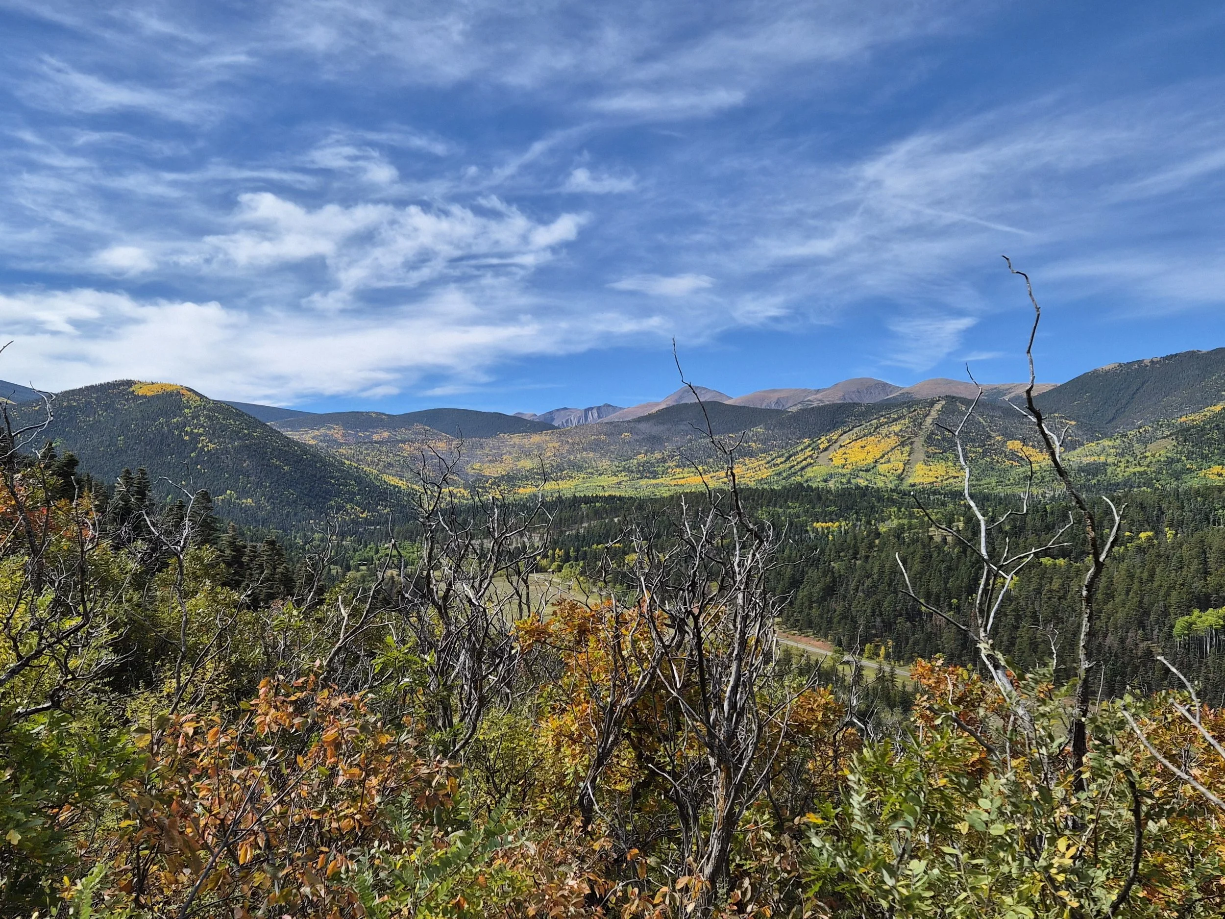
Come join us to run through a magical part of history in the Cuchara Valley. The Spanish Peaks of Southern Colorado have been among the most important landmarks of the southwestern United States, guiding Native American tribes, Spanish and French trappers, gold seekers, hunters, and American settlers.
The Ute, Comanche, Apache, and other, earlier Native American tribes held the peaks in religious awe and named the mountains Wahatoya, meaning “Breasts of the Earth.”
Our event will be pairing with both the town of La Veta and Cuchara to help them celebrate their annual Oktoberfest.
We will have a 50K, heavy half marathon, and 8ish mile event that traverse through San Isabel National Forest land. The 50K will start in the town of La Veta, wrap itself through the middle of the town, onto a rugged out of commission county road with sweeping views of the dikes, buttes, and mountains in the surrounding areas. You will end on newly reopened and maintained trails that guide you straight into town ending with a festival at the Cuchara Yacht Club. The heavy half and 8 mile will start on private property, take on the Dike trail and some other local favorites, to end back under the arch at the Yacht Club to join the party.
We will be partnering with the local brewer to provide finish line beers, and other local businesses to provide five star accommodations, live music from local talent, and great food.


Start: Please note that the starting line if different for the 50k and the 8mile/Heavy Half
Start 50k: La Veta Highschool 200 East Stadium Drive, La Veta, CO 81055Start 8 Mile/Heavy Half: Cuchara Yacht Club30 Cuchara Ave, La Veta, CO 81055Cost:
50k: $100 Heavy Half Marathon: $758ish Mile: $50Course Info:
There are three different distances for this race, an 8ish Mile, a Heavy Half Marathon, and a 50k. All three courses share the same finish from the south trailhead of the Dike Trail in to the local’s favorite The Cuchara Yacht Club!
8ish Mile:
Distance: 7.6 Miles
Elevation Gain: 1,626 ft
Max Elevation: 9,434ft
Route Description:
Runners will leave the yacht club and work their way through a small neighborhood of dirt roads, and summer cabins till they reach the North Trailhead of the Dike Trail. Here they will face their first challenge, which are the steep set of stairs to get on the official trail. Once up the stairs, you will climb for the first 2.4 miles on the heavily shaded trail for just under 900ft. Before you start heading down the switch backs to the aid station don’t forget to take in the views of Raspberry Mountain and the Cuchara Ski Resort. After making your way down the switch backs you will find your fully stocked aid station complete with helpful volunteers. Once checked in with the aid station timers, you will turn around and head back the way you came.
The climb will be faster and steeper coming back in this direction and then have a slow runnable descent to the cabin filled neighborhood to return to scents of BLTs & Octoberfest beers, and sounds of people cheering and bands at the Yacht Club Finish. Enjoy a beer, some friends, and yummy eats before heading back to your hotel or campsite.
Route Turn by Turn Directions:
Start at the Yacht Club. Right out of Yacht Club on Cuchara Ave. Right on City Ave. Left on South City Ave. Left on Hill Road. All of these roads are well maintained dirt roads. Slight Right on to Dike Trail. This will be a well marked trailhead that has a few stairs off the main road to get on to the actual trail. You will continue with most of your gain here, in a shaded heavily wooded area. This trail is entirely maintained by the La Veta Trails group, with permission from the San Isabel Forest and they do an amazing job. Continue to Dike Trail South Trail Head while taking in sweeping views of the Cuchara Ski Resort, Raspberry Mountain and the surrounding area. You will continue downhill on some long switch backs until reach the Only Aid Station - Dikes Trail South TrailHead (@ mile 4). You will then return along Same Path to Yacht Club, to enjoy your finisher award, live music, food & beer for purchase.


Heavy Half Marathon:
Distance: 14.6 Miles
Elevation Gain: 3,199 ft
Max Elevation: 10,634 ft
Route Description:
After starting in the Yacht Club where you will get a glimpse of the finish line festivities being set up, you will leave town on the back roads thru adorable river side cabins to make your way to the first road crossing. This will place you on to the Spring Creek Trail, there will be a water stop here, in the event that you did not grab enough at the start line. You will begin your first big of the race in an open sunny trail with some water crossings, and interesting red rock formations. Don’t forget to turn around occasionally and peek at the Wahatoya themselves. You will soon sit some two way traffic as the 50k runners make their way down to the Spring Creek Trailhead. Careful to pay attention to your gpx and trail markings as you will be making a different turn than they do. You will make your way to your left hand turn onto the Short Cut Trail to cut across the mountain. You will be in and out of shade, thick lodge pole pine grooves, and Aspen. Enjoy all the fall colors as you make your way to your second aid station at the Cuchara Ski resort. Upon your second left hand turn on the Baker Trail enjoy the water crossings, views of the Spanish Peaks while winding your way through a fairy garden (if you believe the signs) and the heavily wooded area as you make your way down to the air station at the Ski Resort. This is the only spot along the course that you can see your crew or family/friends can spectate. After you have fueled up at the aid station, you will be running along a road where there is some traffic so please be aware, abide by the rules on the road, and run towards oncoming traffic. After your last road crossing you will be on the home stretch. The South Dike Trail aid station will be open and ready for business so fuel up for the last real climb of the race. The climb will be short and steep on this side to get back to the high point of the 8 mile course where you will be treated with views of the ski resort you just came from. After you get to the top it is mostly downhill in shaded trails till you return back to the Yacht Club for well earned beer, food, and music.
Route Turn by Turn Directions:
Start at the Yacht Club. Right out of Yacht Club on Cuchara Ave. Right on City Ave. Left on South City Ave. Right on Brook Lane, right on Brook Drive (all of the roads up until this point are well maintained dirt roads) right on Highway 12. There will be a volunteer out there helping to direct you along the highway. You are only running along the grassy shoulder for a few hundred feet before turning left at Spring Creek Trailhead. Right at First Junction on to 1302 (Dodgeton Creek)this is where the trail will start to climb towards the junction with the 50K course. Continue on 1302 Straight Thru all Junctions to stay on 1302 (Dodgeton Creek). Straight at Dodgeton Creek & Indian Creek Trail to continue on Indian Creek Trail. Left at Indian Creek Trail & Baker Creek Trail Junction to Continue on Baker Creek Trail, please be careful as this is where the 50k folks will join the course from above you. Right At junction down to Cuchara Ski Resort Parking lot. Aid Station 1 - Baker Creek Trail @ Cuchara Mtn Resort TH (7.5-8ish mile ). Runners continue down Panadera Ave, this is a in use road, so please keep your eyes peeled, and maintain awareness of cars. At the Highway 12 junction, you will see another volunteer leading you down a social trail that connects to the neighborhood across the street. You will take a left on to Britton Trail. Right on Ponderosa Road, to a quick left on to Park Road, Continue to follow Park Rd until you see the second aid station at the entrance to the Dike Trail. Aid Station 2 - Dikes Trail S TH (Same one used for 50k & 8 Mile @ Mile 10). Runners turn on to Dike Trail Marked by Aid Station, slight Left on Oak Street after exit Dike Trail, right on South City Ave, right on City Ave left on Cuchara Ave to Finish in the Yacht Club to enjoy your finisher award, live music, food & beer for purchase.


50k
Distance: 32.4 miles
Elevation Gain: 6,709ft
Max Elevation: 11,147ft
Route Description:
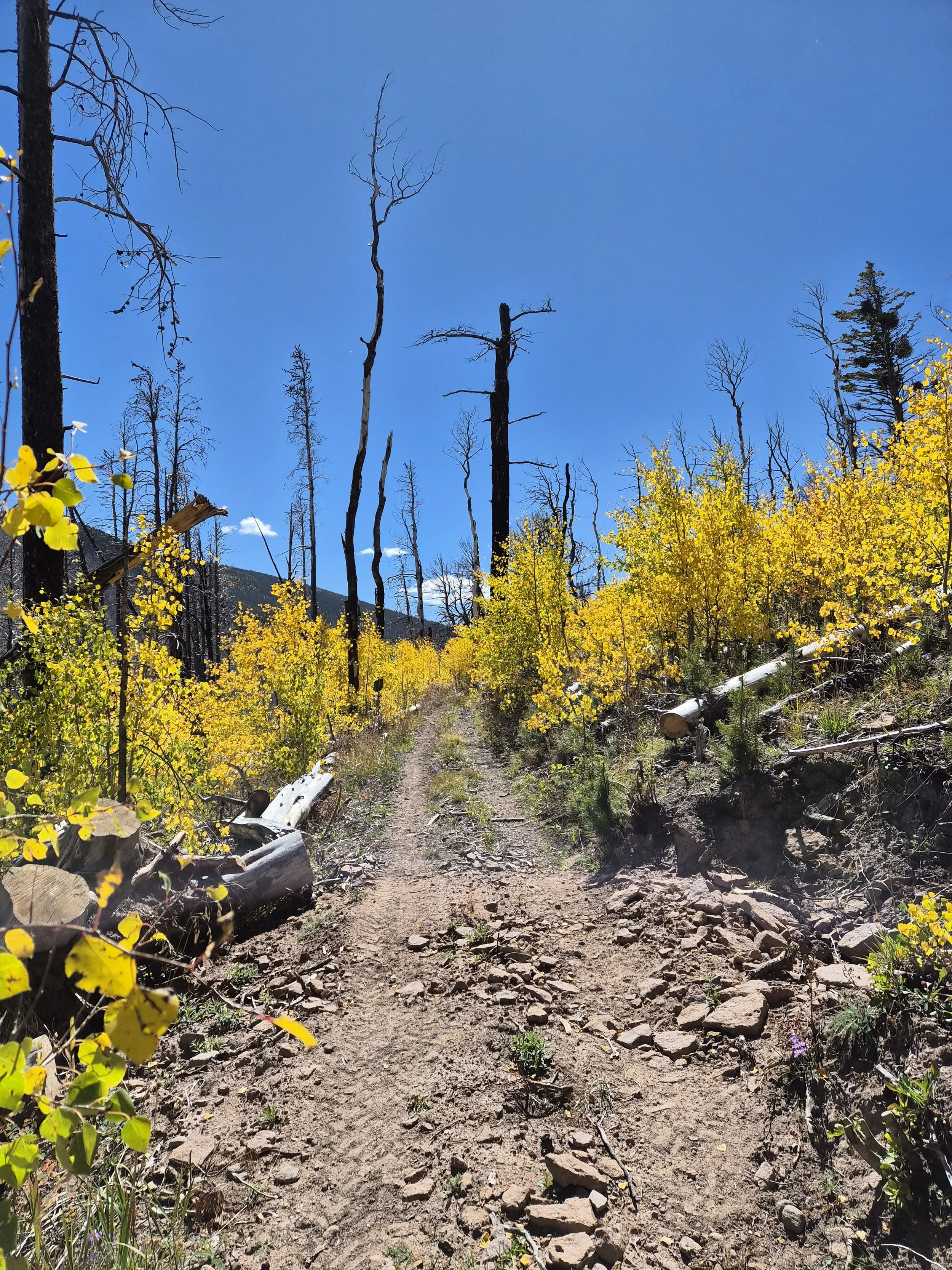
Runners will be started at the La Veta High School and quickly exit town while passing the local deer families. Once out of town you will be on a low trafficked country road, that will be mostly runnable with only 1019ft of gain while you watch the sunrise and enjoy sweeping views of East and West Spanish Peaks to your left along with Mount Mesta and Silver Mountain on your right. The road is an easement on private property, so runners must take care to not trespass on the road sides. You will reach the first aid station and the start to a slightly more adventurous track as you progress through past years and the most recent flood plain. The course will be heavily marked in this section, as you pass through the first gate you are no longer on private property and can feel free to fill water bottles, or cool off in the running water in this section. This was an old country road still that is no longer in use due to flooding, there are 4 water crossings in this 1.7 mile section that you can’t avoid, but can easily keep your feet dry. There are a few others that you can easily step over, but can still be used for a quick cool down. Don’t forget to keep an eye out for the little waterfall on the left. This section of the course will require a bit more route finding, although it is still easily recognizable where the trail goes and will be more heavily marked (again this is only a small 1.7ish mile spot). This section of the course will also start the area of the forest that was most affected by the Spring Creek Fire of 2018.
Next runners will turn left at the large trailhead sign for Indian and start the real climb of the route. Runners will climb through old burn out area for the next 6 miles gaining 2,870ft, don’t forget to look behind you as you are treated with more views of the earlier mountains, and even sneak peeks of Blanca and Little Bear (Colorado 14ers). As you gain the ridge in the first 3 miles, and flatten out for a minute you can also look to your left and see how far the Spring Creek Fire made it up Raspberry mountain with an almost perfect line “drawn” where the fire stopped. This section was cleared (as it was previously described as having many downed trees) with much help from some locals. As you head into the shade and continue up perfectly maintained trails to the top of Raspberry Mountain, a few last switch backs will lead you to the high point of the course. Next you will enjoy runnable downhill with initial glimpses of the ski resort and the Spanish Peaks. From the high point it is a little less than 3 miles to the water stop at Forbes Park. Runners will see a junction marked by race directors leading them to the out and back water stop. It is important that runners complete this round trip no matter what their water status is, as there is a safety check at this stop.
Once returned to the Indian Creek Trail you will be treated with more shade, well maintained trails, and dense lodge pole forests. The next stop is the Spring Creek Trailhead where there will be another limited aid station as well as an unofficial crew stop your friends and family can meet and resupply you at. After this short stop the trail will work its way across the hillside offering sweeping views of the Spanish Peaks and parts of the town of Cuchara where your race ends. As you make your way across the hill, enjoy dense Aspens, fern Fairy gardens, and rolling terrain. Don’t miss the sharp left turn to make it down to a fully stocked aid station and official crew point at the Cuchara Ski Resort parking lot.
After feeling fully refueled you will make your way to the final climb on the Dike Trail. Runners will share the road with crew, and neighborhood drivers as they continue down Panadero Ave to your only road crossing. As you continue thru the neighborhood to your final aid station at the South Trailhead of the Dike Trail. Some quick switch backs will have you on your way up the final climb to another view point of the Ski Resort and the front half of the course you came from. Enjoy peeks of the rock formations that are the Dike. As you make your way to the end of this trail be aware of the stairs to get down to the dirt road into town. At this point you should be able to smell the Octoberfest Beer, and hear the tunes from the Yacht Club Finish. Turn the corner onto Cuchara Ave, and enter for beer, music, fun, finisher prizes and food!

Route Turn by Turn Directions:
Start at La Veta High School Parking Lot. You will then quickly wind your way through the Town of La Veta to the county road. Left on North Main Street. Right on West Moore/Park Street, continue on South Oak Street. Right on West Francisco Street to a left on South Aspen Street followed by a quick right on County Road 430. Slight Left on County Road 421. First Aid Station at Mile 7 (Private Property on County Road 421 - we have special permission to have our aid station here). Continue on 421 past old Sulphur Springs, Hope Gulch, Tracy Canyon. Left and then a quick right on Indian Creek Trail (1300). Aid Station 2 - intersection of Indian Creek trail and Forbes Park TH access (this is a water only aid station and is a 0.80 mile (one way) out and back to get to the aid station). Once you are back from the water stop you will continue on Indian Creek Trail. You will take a left on to Dodgeton Creek Trail 1302. You will take a left the first time at the next junction to continue on the Dodgeton Creek Trail and hit Aid Station 3 - Spring Creek Trail (Limited Aid). You will back track to the Junction of the Dodgeton Creek Trail and Baker Creek Trail and this time take another left on to the Baker Creek Trail (1301). Aid Station 4 - Baker Creek Trail & Cuchara Mtn Resort. Runners will continue down Pandero Ave, and cross the street on to Britton Trail. Right on Ponderosa Road, followed by a quick left on Park road. Aid Station 5 - Dikes Trail S TH (will also be used for Heavy ½ & 8 mile). Runners turn on to Dike Trail Marked by Aid Station. Slight Left on Oak Street after exit Dike Trail. Right on South City Ave. Right on City Ave. Left on Cuchara Ave to Finish in the Yacht Club


Race Rules
Leave no trace. Better yet, leave the trails better than you found them (pick up any trail trash that you see along the way-free Trail Trash Trucker hat to the runner who picks up the most trash mid-race!) No littering. Anyone intentionally littering will be disqualified.
Stay on course. If you get off course, please do your best to return to where you went off course and continue along your designated loop.
Be Kind. Anyone who is rude to other runners/staff/park staff/crew will be disqualified.
NO COMPLAINING - this is an adventurous undertaking, we assume that you are going to be responsible for yourself, this includes getting information before race day, and having the course gpx on at least one device.
Check in. If you are going through and aid station that is manned by volunteers, make eye contact with them, and make sure that they get your bib number.
No dogs on the course.
No Pacers.
Crew cannot administer aid to their runner outside of the main aid station. Crew can sit at road crossings and cheer people on.
In case of muddy or wet trail conditions (it is the end of September so we don’t expect this) please run directly through the muddy section. It’s counterintuitive but running around the mud widens the trail unnecessarily and negatively impacts the areas adjacent to the trail.
Mandatory Gear. Please see the list for each race distance.
We don’t disallow headphones, but we do recommend that you keep at least one of them out or use the bone conduction type. You are running in a remote area in the wilderness. There is wildlife. It is good practice to be on alert.
HAVE FUN!
Special Thanks to Our Partners


FAQ:
How will I get from the start to the finish if I have no crew:
There will be a shuttle that will run from parking at the finish line to the start for the 50K on Saturday morning. More information will be in the pre race email.
Where do I park for 8 Mile & Heavy Half:
We will be using private property for parking, and there will be more information in the pre race email. Parking will be about a quarter mile walk to the start/finish line. Ww are asking that runners, family, and crew do not park along Cuchara Ave unless you are staying at the room at the Yacht Club or Cuchara Lokal Inn.
What SWAG Do I Get:
Runners will receive a custom finisher award for each distance, Trail Trash Stickers, Two Toms Sample, LMNT Samples, Trail Toes Samples, MyCoLove Farms Samples, and a finisher beer
Why isn’t a shirt included in my entry fee:
We have determined that many people would rather have a slightly lower race fee, than have a shirt included in the cost. So in order to keep our races more accessible to everyone, you have a option to purchase a race day shirt, that is an offset cost based on our orders.
What wildlife might I encounter on the trails:
Cuchara and La Veta are home to a lot of different wildlife. Outside of town the animals are not used to seeing many people, and will be more skittish. The area is home to black bears, elk, deer, fox, skunks, grouse, lizards, snacks, and many different bird species to name just a few.
Places to Stay:
*Please note that these are not the only places to stay, but they are the places that we have personal experiences, or relationships with and that we are recommending based on those experiences
Hotels:
Rooms at The Club: https://www.roomsattheclub.com/
Cuchara Lokal Hotel: https://www.cucharalokalhotel.com/
La Veta Inn: https://lavetainncolorado.com/
Camping:
Lathrop State Park: https://cpw.state.co.us/state-parks/lathrop-state-park/lathrop-state-park-camping-lodging
Blue Lake Campground: https://www.recreation.gov/camping/campgrounds/254082
Sulphur Springs Ranching Camping: 5218 County Road 421 La Veta CO. Contact Robert: 920-238-7719
Places to Eat:
*Please note that there are again other places to eat in town, but these are places that we have great experiences at, and also that we have personal connections with.
Yacht Club (The main partner of our event): https://www.cucharayachtclub.com/
Legends on Main: https://www.stianoitalian.com/
Lokal Perks Coffee: https://www.facebook.com/p/Lokal-Perks-100084271105510/